With a population approaching 300,000 and a metropolitan area exceeding 2.8 million, St. Louis sits at an elevation averaging 466 feet above sea level along the Mississippi River’s western bank. Subsurface conditions here shift dramatically within a single city block—from deep alluvial silts near the riverfront to stiff loess-covered limestone residuum farther west. An exploratory test pit provides direct visual access to these strata, allowing the geotechnical team to map fill thickness, identify relict sinkhole features, and collect undisturbed block samples. In a city where the Paleozoic bedrock surface undulates by more than 30 feet over short distances, seeing the soil profile in full section eliminates the interpretive gaps that borehole logs alone can leave. When karst weathering is suspected beneath a planned footing, combining a test pit with a CPT test helps define the transition zone between competent rock and softened clay seams.
In the St. Louis karst terrain, one well-logged test pit reveals more about rock-head variability than four borings spaced 20 feet apart.
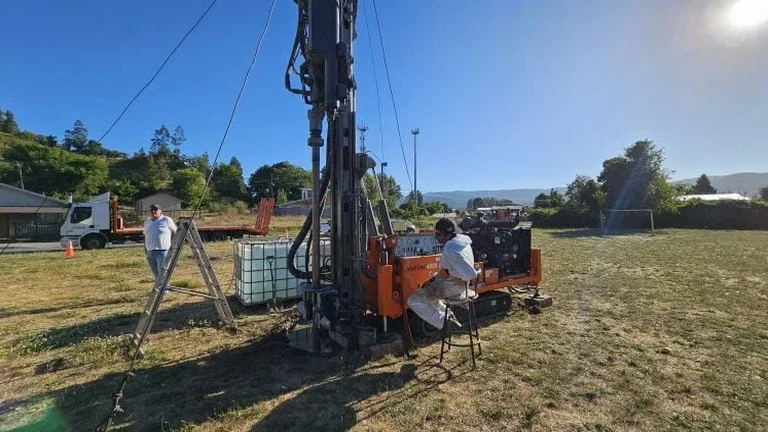
Process and scope
Local ground factors
A five-story mixed-use building on Manchester Avenue required foundation deepening after test pits revealed buried demolition debris extending 11 feet below the sidewalk line. The original geotechnical report—based solely on borings—had assumed native loess at 6 feet. What the pit faces actually showed was a chaotic fill layer containing brick fragments, charred timber, and pockets of ash from the 19th-century structures that once occupied the site. Excavating the pit also triggered a small sidewall collapse in the saturated fill, underscoring why OSHA’s competent-person inspection is non-negotiable on urban infill lots. Beyond debris mapping, exploratory pits in St. Louis routinely encounter perched groundwater lenses within weathered limestone that standard monitoring wells do not capture. Overlooking these lenses leads to wet basements, buoyancy problems, and sulfate attack on concrete. A single well-placed pit, logged by an experienced field geologist, catches what a dozen split-spoon samples can obscure.
Reference standards
ASTM D2487 – Standard Practice for Classification of Soils for Engineering Purposes (Unified Soil Classification System), ASTM D2488 – Standard Practice for Description and Identification of Soils (Visual-Manual Procedure), OSHA 29 CFR 1926 Subpart P – Excavations, IBC 2024 (adopted by St. Louis County) – Chapter 18 Soils and Foundations, ASCE 7-22 – Minimum Design Loads and Associated Criteria for Buildings and Other Structures
Associated technical services
Standard Exploratory Pit (6–12 ft depth)
Single-benched excavation for visual soil profiling, bulk sampling, and in-situ density testing in accessible open terrain. Typical for single-family residential additions in St. Louis County.
Deep Investigative Pit with Shoring (12–18 ft)
Stepped or trench-box-supported excavation for deep footing inspections and karst feature delineation. Applied where limestone pinnacles or solution-widened joints are anticipated.
Interior Slab Test Pit
Low-headroom mini-excavator entry through existing warehouse or commercial building slabs. Used for adaptive reuse projects in the Central West End and Downtown loft conversions.
Forensic & Pavement Section Pit
Narrow trench-style pit to expose pavement base course, subgrade, and utility bedding. Paired with sand cone density checks for roadway failure investigations.
Typical parameters
Questions and answers
What does an exploratory test pit cost in St. Louis?
For a standard single pit excavated to 8–12 feet with backfill and surface restoration on accessible terrain, budgets typically range from US$460 to US$830. Cost varies with depth, shoring requirements, spoil disposal fees, and traffic control if the pit is within a public right-of-way.
How deep can a test pit go before shoring is required?
Per OSHA 29 CFR 1926 Subpart P, any excavation deeper than 5 feet in Type B or C soils—common in St. Louis river-deposited silts—must have a protective system. In practice, we bench back at 1.5H:1V for pits exceeding 4 feet and install trench boxes beyond 12 feet after a competent person evaluates the face stability.
Can a test pit detect karst features in St. Louis County limestone?
Yes—a test pit is one of the most effective reconnaissance methods for identifying relict sinkholes, clay-filled solution cavities, and pinnacled bedrock. Exposing the rock-head contact across a 10-foot-wide excavation reveals the irregular weathering profile characteristic of the St. Louis Limestone formation, which core drilling alone may miss.
What backfill compaction standard applies after the pit is closed?
We compact backfill in 8-inch lifts to a minimum of 95% of Standard Proctor maximum dry density (ASTM D698) when the pit lies within a future building footprint. For landscape areas, 90% compaction is generally sufficient. Nuclear density gauge readings are taken on every third lift and documented in the closure report.