Slope conditions vary dramatically across the St. Louis metro area, and the contrast between the low-lying floodplain soils near the Mississippi River and the steep loess-covered bluffs in neighborhoods like Soulard or Compton Heights makes that clear. A cut that stands perfectly stable in well-drained limestone residuum may require completely different reinforcement just two miles east where collapsible loess predominates. Our team has spent years analyzing these local transitions, and we know that a generic safety factor calculation doesn't capture what happens when a St. Louis slope gets saturated after a spring storm. We combine field investigation with laboratory testing under ASTM D1586 and D2487 to build models that reflect the actual stratigraphy beneath your site, so the retaining wall or drainage solution we recommend fits the ground you're building on, not a textbook example.
A St. Louis slope doesn't fail because the math was wrong—it fails because the water was underestimated. We model saturation scenarios that reflect actual Missouri rainfall records.
Process and scope
Local ground factors
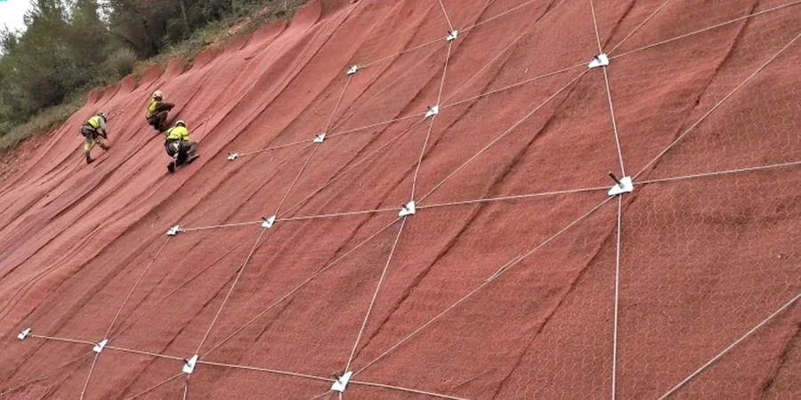
The expansion of St. Louis during the late 19th and early 20th centuries pushed residential and commercial development onto the bluffs that earlier settlers had avoided, leaving a legacy of marginally stable cuts and poorly documented fills throughout older neighborhoods. Many slopes that have stood for decades are now showing distress because small grading changes on adjacent lots altered the surface water flow—a problem that existing site plans rarely reflect. The biggest financial exposure for a developer or builder comes not from the cost of analysis, but from the cost of a slide that takes out a public right-of-way or exposes a neighboring foundation. Our reports are structured to provide clear, actionable stabilization alternatives—whether that means soil nailing, mechanically stabilized earth, or regrading with benching—so the owner can make a risk-based decision with full understanding of the construction cost and long-term performance implications. We also address the seismic demand explicitly because the New Madrid Seismic Zone, while distant, still imposes a design ground motion that can reduce the factor of safety below acceptable thresholds in saturated slope conditions.
Reference standards
ASCE 7-22 (Minimum Design Loads), IBC 2021 (Chapter 18 soils and foundations), ASTM D1586 (Standard Penetration Test), ASTM D2487 (Unified Soil Classification), ASTM D3080 (Direct Shear Test), FHWA NHI-06-088 (Soils and Foundations Reference Manual – Vol II)
Associated technical services
Design-Level Slope Stability Modeling
For final engineering and permitting, we prepare detailed limit equilibrium and finite element models calibrated to site-specific subsurface investigation results. The report includes critical slip surfaces, pore pressure distribution, sensitivity analyses, and specific recommendations for reinforcement, drainage, or geometry modification. Suitable for retaining wall design, roadway cuts, and residential hillside development.
Forensic Slope Failure Investigation
When a slope has already moved, we deploy inclinometers, piezometers, and exploratory borings to determine the failure plane depth and trigger mechanism. The deliverable is a stabilization design that addresses the root cause—not just the visible scar—so the repair stands up to the next heavy rain or freeze-thaw cycle.
Typical parameters
Questions and answers
What does a slope stability analysis cost for a typical St. Louis hillside lot?
For a single-family residential lot on a St. Louis bluff, a complete analysis including borings, lab testing, and the engineering report typically ranges from US$1,430 to US$4,450. The final cost depends on access conditions, the number of borings required to define the stratigraphy, and whether we're analyzing an existing slide or a proposed cut.
Do I really need a slope stability analysis for a small addition on a hillside?
Yes, and the St. Louis County building department will almost certainly require it if your addition is within the influence zone of a slope steeper than 3:1. The analysis confirms that your excavation and new loading won't reduce the factor of safety below code-minimum thresholds, which protects both your investment and your neighbor's property.
How long does the analysis take from start to finish?
A typical design-level analysis takes three to four weeks: one week for field drilling and sampling, one week for laboratory shear strength testing, and one to two weeks for modeling and report preparation. Forensic investigations of active slides may take longer if we need to install and monitor instrumentation over several rainfall events.
What stabilization options do you typically recommend for St. Louis loess slopes?
The most common solutions we design include subsurface drainage systems (horizontal drains or toe drains) to lower the phreatic surface, soil nailing or tieback anchors for reinforcement, and regrading with benches to reduce the driving force. The recommendation depends on the failure mechanism identified in the analysis—drainage alone often solves the problem when poor water management is the trigger.