St. Louis tunnel projects face a distinct set of subsurface challenges that demand more than a routine look at the ground. The city sits right where the Mississippi River has left behind deep, layered deposits of soft alluvial clays and silts, and these materials behave very differently under the pressure of tunneling than the limestone most people associate with Missouri. When we evaluate a proposed tunnel alignment here, the starting point is always the framework established by ASCE 7 and the IBC, but the real work lies in interpreting how those codes apply to a profile that often includes pockets of organic material, loose sands, and a water table that sits surprisingly high. The variability we encounter—sometimes within just a few hundred feet along the alignment—makes a detailed CPT program an early step we recommend before any major excavation, because it gives a near-continuous read on where the soft spots actually are.
St. Louis soft ground does not announce itself—the transition from competent clay to sensitive silt can happen in less than a tunnel diameter.
Process and scope
Local ground factors
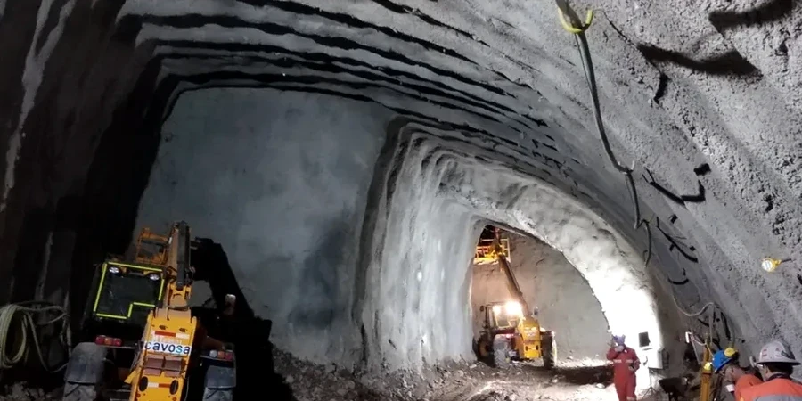
St. Louis sits roughly 466 feet above sea level, but what matters for tunneling is how close you are to the river—and how that elevation relates to the water table. In neighborhoods like Carondelet or along the North Riverfront, the groundwater can be sitting just 10 to 15 feet below the street, which means a tunnel crown at 30 feet of depth is already well into saturated, low-strength material. The risk we flag most often for local projects is not a sudden collapse but a slow, progressive squeezing that closes the heading over hours or days. It happens when the soft clay yields under the stress relief of excavation, and if the face support is not dialed in, surface settlement can propagate up to the foundations of brick row houses and commercial buildings that were never designed for differential movement. The combination of sensitive clays, a high water table, and an urban environment with aging infrastructure makes this one of the more unforgiving tunneling environments in the Midwest.
Watch the video
Reference standards
ASCE 7: Minimum design loads for buildings and other structures, IBC (International Building Code): Chapter 18 on soils and foundations, ASTM D1586: Standard test method for SPT and split-barrel sampling, ASTM D2487: Standard practice for classification of soils for engineering purposes, ASTM D4767: Standard test method for consolidated-undrained triaxial compression
Associated technical services
Subsurface Investigation for Tunnel Alignment
A combination of mud rotary borings, CPT soundings, and selective Shelby tube sampling to characterize the alluvial profile along the proposed drive. We map the top of the soft clay, locate paleochannels, and install piezometers to track seasonal groundwater fluctuations tied to Mississippi River stage.
Laboratory Strength and Deformation Testing
A testing regimen built around the specific failure modes of soft ground tunnels: consolidated-undrained triaxial with pore pressure measurement, one-dimensional consolidation to define the compression index, and Atterberg limits to confirm the plasticity characteristics that control squeezing behavior.
Tunnel Face Stability and Settlement Analysis
Using the ground model developed from field and lab data, we run analytical and numerical assessments of required face support pressure, potential ground loss, and the settlement trough that would develop at surface—critical for protecting the brick and masonry structures common in St. Louis's older neighborhoods.
Typical parameters
Questions and answers
What makes St. Louis soft ground different from soft ground in coastal cities?
The difference is largely depositional. Coastal soft clays often come from marine or estuarine environments and tend to be more uniform. St. Louis soft ground is fluvial—deposited by the Mississippi River—so it is heavily layered and cut by old channel scars. We find lenses of sand and silt mixed into the clay, and the water table is directly tied to river level, which can fluctuate 20 feet or more seasonally. That makes the ground response during tunneling less predictable than in a thick, uniform clay deposit.
What laboratory tests are most critical for a tunnel through soft clay in St. Louis?
We prioritize consolidated-undrained triaxial tests with pore pressure measurement, because they give us the undrained shear strength and the stress path behavior that governs face stability. One-dimensional consolidation tests are also essential to define the compression and recompression indices, which feed directly into the settlement predictions. Atterberg limits round out the picture by confirming the plasticity of the clay and how sensitive it is to remolding.
What is the typical cost range for a geotechnical investigation for a soft ground tunnel in St. Louis?
For a tunnel alignment in the St. Louis area, the geotechnical investigation typically ranges from US$4,280 to US$15,200, depending on the length of the alignment, the number of borings and CPT soundings required, and the extent of laboratory testing. Shorter drives with fewer access constraints fall toward the lower end, while longer alignments through developed urban corridors with extensive lab programs fall at the upper end.
How do you handle the risk of running into old infrastructure or uncharted fill along a tunnel alignment in St. Louis?
Old infrastructure is a real concern in a city with St. Louis's history. We start with a thorough desktop review of historical maps, utility records, and previous geotechnical reports from the corridor. In the field, we may supplement borings with geophysical methods like ground penetrating radar or electrical resistivity to flag anomalies between boreholes. If we suspect fill or buried structures, we add targeted test pits or larger-diameter borings to confirm what is there before the tunnel machine ever reaches that point.